
We are using cookies.

We are using cookies on this web page. Some of them are required to run this page, some are useful to provide you the best web experience.

I accept

Individual Cookie Settings

Only accept required cookies.

Privacy Notes Imprint

Privacy settings

Here is an overview of all cookies use

Cookies for Statistics

Statistic cookies anonymize your data and use it. These information will help us to learn, how the users are using our website.

Show Cookie Informationen

Google Conversion-Tracking-Tag

Save

BackOnly accept required cookies.

Privacy Notes Imprint

  • Jump to main menu
  • Jump to side menu
  • Jump to content
  • Jump to footer
  • Contrast
  • de
  • en
Logo htw saar – To homepageLogo htw saar – To homepage
Search
  • Projekte
  • Hangrutschmonitoring LHS Saarbrücken
  • AFaktive - Agroforstwirtschaft als Schlüssel zur Verbesserung des Wassermanagements
  • Regenüberlaufbecken Aschbach
  • SER-SL und SEROMO - Starkregen- und Bodenerosionskarten für das Saarland
  • Überflutungsrisikoanalyse für kritische Infrastruktur
  • Zukunftsaufgabe Digitaler Wasserzwilling
  • Contact
  • Locations
  • Library
  • Canteen menu
  • Moodle
 
  • htwsaar
  • Research and transfer
  • Forschungsprofil
  • Kompetenzzentren
  • KoK²
  • Projekte
  • Zukunftsaufgabe Digitaler Wasserzwilling

A Future Challenge: The Digital Water Twin

A forward-looking project currently in the planning stages at KoK² is the Saarland Digital Water Twin. Public authorities at the state, county, and municipal levels, as well as those in disaster management and fire departments, and planning firms face a multitude of challenges. Given the constraints on financial, technical, and human resources, further digitization in water management is essential. A digital twin can also serve to inform the public, for example, through 3D visualizations of water level data.

This is because, for many issues in water management, geodata and its processing—for example, for designing retention measures, creating heavy rain and flood hazard maps, or in operational planning—constitute indispensable foundations. Currently, this data is requested and processed by the respective users at the relevant agencies for specific tasks. This process ties up resources for tasks that could largely be automated.

In the future, all of this data will be made available to the respective users via a standardized interface. For water management issues, automated calculations using the data should also be made possible immediately. Flood hazards should be communicated to citizens not only through water level data and 2D maps, but also in a 3D environment using an easy-to-understand visualization.
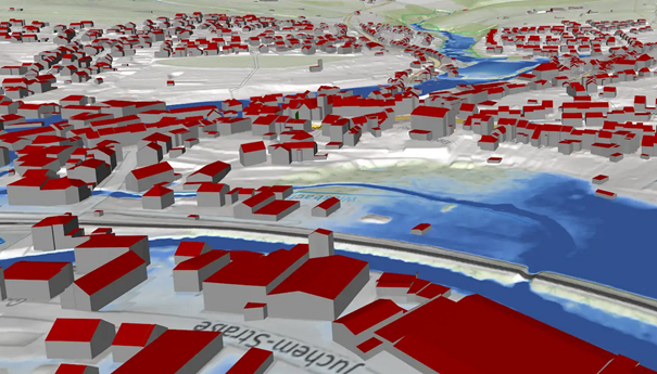
Image: 3D visualization of floodplains (Source: KoK²)

Auszeichnungen und Partner der htw saar

footer area

  • Impressum
  • Datenschutz
  • Erklärung zur Barrierefreiheit
  • Cookiesettings

Socialmedia

  • Facebok
  • Instagram
  • LinkedIn
  • youtube
  • flickr
  • blog

Contact us

Saarland University of Applied Sciences

Goebenstraße 40
66117 Saarbrücken

Telephone: (0681) 58 67 - 0
Fax: (0681) 58 67 - 122
E-mail: infonoSpam@noSpamhtwsaarnoSpam.de

Locations

  • Campus Alt-Saarbrücken
  • Rotenbühl Campus
  • Campus Göttelborn
  • HTZ at the Saar Innovation Campus

htw saar

  • Press releases
  • Announcements
  • Semester dates/lecture times
  • Working at the htw saar
  • First aid / fire protection
  • Occupational health and safety (AGUM)
  • IT emergencies
  • Radiation and laser protection
  • Webmailer
  • Intranet (for employees)
  • Login (for employees)

Supervisory authority:
Saarland Ministry of Finance and Science